




Heating and cooling buildings account for over a quarter of UK CO2 emissions, and the country has deployed almost none of the shallow geothermal energy that could displace fossil fuels in that sector at scale.
The gap is not primarily technical; it is a knowledge gap. Developers, planners, and regulators lack the subsurface data needed to assess geothermal viability, design aquifer thermal energy storage systems with confidence, or satisfy environmental requirements about interference between adjacent schemes. The British Geological Survey’s release of 17 borehole data packs and a drilling report from the Cheshire Observatory, the final major deliverable from the £31 million UK Geoenergy Observatories programme, is the most direct attempt to close that gap yet produced in the UK.
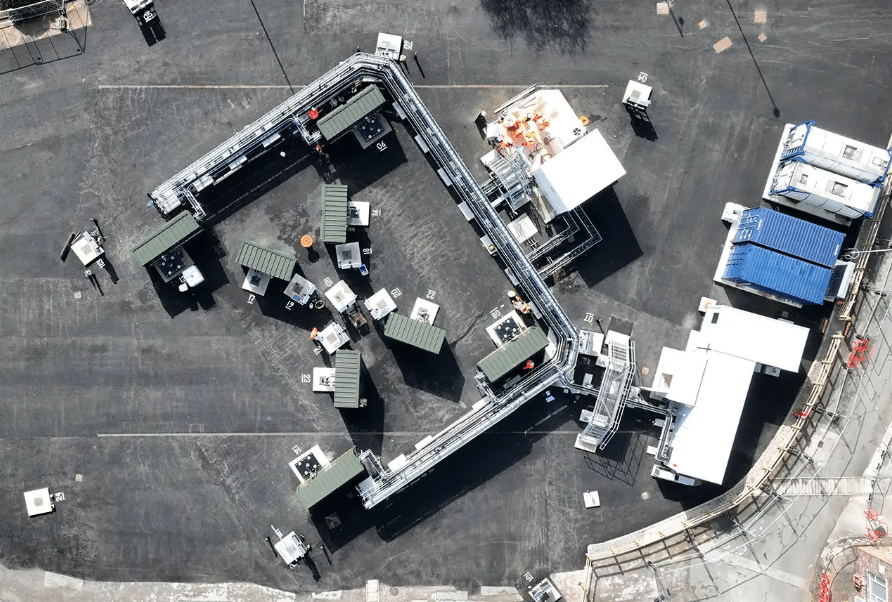
The Cheshire Observatory, opened in April 2024 at Thornton Science Park within the University of Chester, comprises 21 research boreholes drilled to approximately 100 metres into the Sherwood Sandstone Formation, collectively monitoring 130,000 cubic metres of aquifer. More than 1,500 subsurface sensors are installed across the network, including advanced fibre-optic distributed temperature sensing and distributed acoustic sensing, geoelectrical resistance tomography, and borehole heat exchangers capable of circulating both heated and cooled fluids. Boreholes at the centre of the array are spaced just three metres apart, enabling three-dimensional mapping of thermal plumes and groundwater flow at a resolution not previously achieved at field scale in a UK aquifer setting.
What the Data Packs Contain and Why It Matters
The 17 newly released data packs, together with three released in 2025, a ground investigation pack from 2023, and a core scanning dataset from 2022, constitute a comprehensive open-access characterisation of the Sherwood Sandstone at the Cheshire site. The packs provide high-resolution data on physical properties including porosity, permeability, and thermal conductivity; geochemistry of formation fluids; and interpreted stratigraphy and structural geology. This is the type of dataset that normally exists only in the proprietary records of oil and gas companies or water utilities, and even then rarely with the spatial density and multi-parameter instrumentation that the observatory installation provides.
The Sherwood Sandstone Formation is the primary reason the Cheshire site was chosen. It is a high-porosity, high-permeability sandstone with good thermal conductivity, making it one of the UK’s most prospective aquifer formations for shallow geothermal energy and aquifer thermal energy storage. The same rock formation extends beneath the North Sea and the East Irish Sea, where it is being assessed as a reservoir for carbon dioxide storage under several offshore CCS projects, and it has also been identified as a potential host for hydrogen and compressed air storage. The data released by BGS therefore has direct relevance to multiple energy storage and carbon management applications beyond the geothermal context in which it was generated.
Aquifer Thermal Energy Storage and the Deployment Gap
Aquifer thermal energy storage works by injecting warm or cool water into a permeable formation during periods of surplus and recovering it when demand requires. In summer, excess heat from cooling systems or solar collectors can be stored underground and retrieved for space heating in winter, and the process can run in reverse for summer cooling. The technique is well established in the Netherlands, Denmark, and Belgium, where thousands of systems are operating in commercial, industrial, and district energy applications. In the UK, uptake has been almost negligible despite geological conditions in several regions that are broadly comparable to productive ATES markets in continental Europe.
The ATESHAC project, funded by the Natural Environment Research Council and the Engineering and Physical Sciences Research Council and currently running experiments at the Cheshire Observatory, is assembling the geoscientific, geoengineering, economic, and social science evidence base needed to understand why UK deployment has lagged and what would be required to accelerate it. The observatory is also the test site for the SmartRes project, led by the University of Leeds, which in November 2025 demonstrated that distributed acoustic sensing can detect thermal changes in the subsurface during geothermal experiments, a potentially significant advance in monitoring capability that would allow operators to track heat plume migration without the cost and disruption of additional drilling.
These monitoring advances are not peripheral refinements. One of the primary regulatory and planning barriers to ATES deployment is the difficulty of demonstrating that a new installation will not interfere with existing groundwater users or adjacent schemes. Current practice relies heavily on numerical groundwater modelling, which requires subsurface parameter inputs that are typically estimated from sparse borehole data. The Cheshire Observatory dataset provides calibration and validation data for those models at a spatial resolution that was previously unavailable, and the DAS monitoring results suggest that future operational monitoring of deployed ATES systems could be achieved at substantially lower cost than current approaches.
The Drilling Report as an Engineering Resource
Alongside the scientific data, BGS has released the full drilling report documenting construction methods, decision trees used when subsurface conditions differed from predictions, and lessons learned from installing 21 closely spaced complex boreholes within a 36-metre by 36-metre footprint. Drilling closely spaced boreholes into a permeable aquifer while maintaining well integrity and avoiding hydraulic short-circuits between adjacent bores is technically demanding, and the challenges encountered at Cheshire, including management of drilling fluids, borehole stability in variable lithologies, and installation of fibre-optic cable arrays to 100-metre depth across multiple wells, have not been extensively documented in the published engineering literature for UK geological conditions.
The practical value of this documentation for the UK geothermal and ATES development community is significant. Commercial ATES installations require similar borehole network configurations, and developers and drillers considering projects in comparable aquifer settings currently have limited UK-specific guidance to draw on. The BGS report fills a gap that would otherwise require either expensive site-specific learning or reliance on methods developed in different geological contexts. Its release on an open-access basis through the UKGEOS website removes a knowledge barrier that has historically been a non-trivial component of early-stage project risk.
CO2 Storage and the Broader Sherwood Sandstone Opportunity
The Sherwood Sandstone’s relevance extends beyond shallow geothermal. The North Sea Transition Authority’s licensing of offshore CO2 storage sites is progressing across formations that include Sherwood Sandstone equivalents, and the data from Cheshire contributes to the subsurface understanding of the formation’s flow properties, geochemical behaviour when exposed to formation water under modified temperature conditions, and capacity for fluid injection and recovery. The BGS notes that findings from the observatory could inform CO2 storage assessments in the North Sea and East Irish Sea, where the same formation underlies several proposed storage sites.
Subsurface multi-use presents both an opportunity and a management challenge. An aquifer that serves simultaneously as a drinking water resource, a potential geothermal reservoir, an ATES medium, a hydrogen storage option, and an offshore CO2 store requires regulatory frameworks capable of managing interactions and precedence between different use types. The Cheshire Observatory data, particularly the hydrogeological characterisation and geochemical monitoring results, provide the empirical foundation for those regulatory assessments in a way that model projections alone cannot. Whether that foundation translates into accelerated deployment across the heating decarbonisation, energy storage, and carbon management sectors it touches will depend on the speed at which the relevant regulatory bodies and commercial developers integrate the dataset into their planning and project development processes.
Add EnergyNews.biz as a preferred source on Google


